Welcome to South Mainland
The narrow peninsula which runs 25 miles south from Lerwick boasts some of Shetland’s most attractive scenery, an extraordinary concentration of archaeological sites, and world-class wildlife attractions in its seabird cliffs, wildfowl lochs, seal rookeries and whale-watching viewpoints.
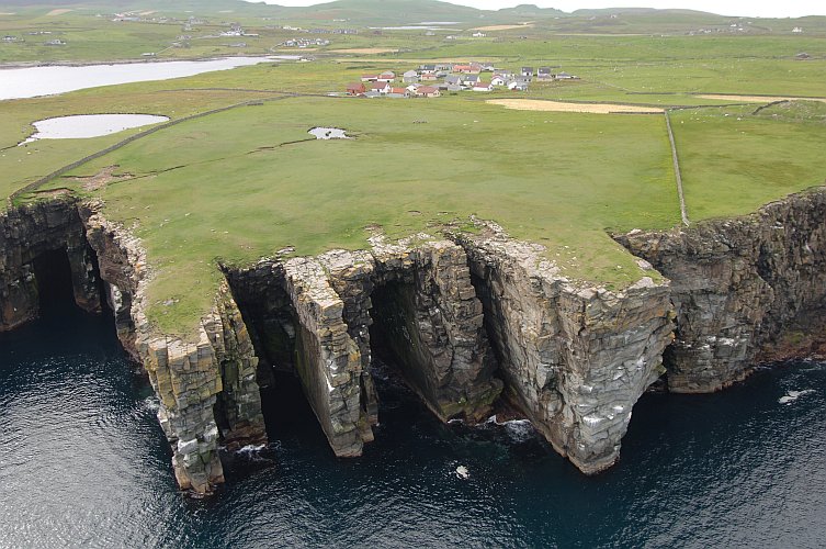 Cliffs at Troswick
 The many side roads off the A970 from Lerwick to Sumburgh make this an ideal area to explore by car. There is excellent walking round the coastline and along the ridge of hills which forms the spine of the South Mainland. The views from summits such as the Wart of Scousburgh and Fitful Head are on an epic scale: crofts and farmland fringe beaches of shell sand and secluded rocky coves; while to seaward Fair Isle and Foula make romantic silhouettes on the ocean horizon.
The shape of the land has mostly been carved by glaciers out of ancient Old Red Sandstone rocks, some 370 million years old, although there are also deposits of soapstone and copper ores. Sandy soil and generations of careful husbandry have made this Shetland’s most productive agricultural district. The South Mainland also has the greatest density of sandy beaches and the sandstorms have helped to preserve archaeological sites such as Jarlshof and Old Scatness.
Throughout the South Mainland there are fascinating traces of the past: small watermills and old croft townships constructed from the area’s beautiful building stone; patterns of ancient field systems; Shetland Ponies whose ancestors carried the peats home for winter fuel; and traditional double-ended Shetland boats whose lines speak of their Viking origins.
Mousa Broch
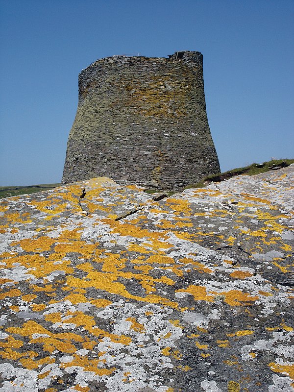 Mousa Broch
 Mousa Broch is the finest surviving example of a 2,000 year old Iron Age tower, or broch. It was one of about 120 built throughout Shetland as times became more troubled. Mentioned in the sagas as an eloping lovers’ hideout, Mousa Broch is one of the wonders of European archaeology. Alamooties (Storm Petrels) nest in its stone chambers. Feeding far out to sea, these tiny swallow like birds return to their nests under the cover of darkness to avoid other larger predatory seabirds. A midnight excursion to see and hear the Storm Petrels is an experience not to be missed.
Mousa abounds in other wildlife: a large colony of Common and Grey Seals basks on the east side of the island; there’s a chance you may see a Dratsi (Otter); Maalies (Fulmars) and Tysties (Black Guillemots) are very common; and Bonxies (Great Skuas), Skootie Alans (Arctic Skuas) and Tirricks (Arctic Terns) defend their nesting grounds by dive-bombing all intruders, humans included - so try to walk round the breeding colonies, for their sakes and yours.
The Mousa ferry leaves from Aithsvoe, Cunningsburgh and the trip is one of the best ways to see Neesicks (Harbour Porpoises) at close range, as they feed on shoals of fish in Mousa Sound.
Crofthouse Museum
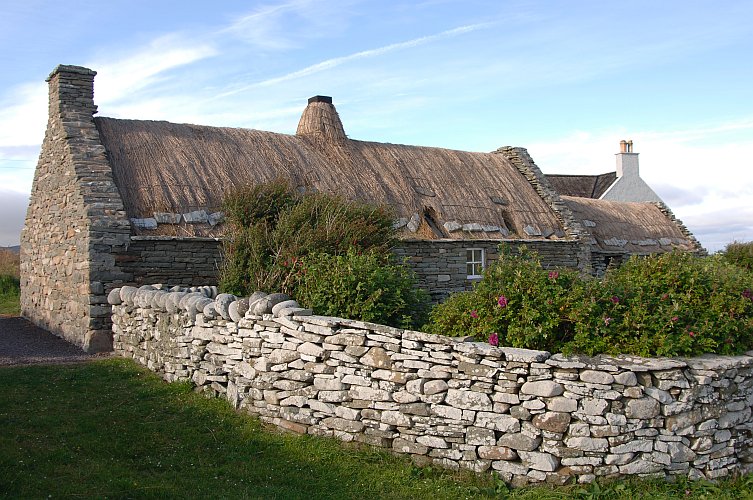 Crofthouse Museum
 South of Boddam, the custodian welcomes visitors at the Crofthouse Museum, a homestead restored as it would have appeared about 100 years ago. Exhibits inside the straw-thatched cottage, barn and byre include home-made furniture, such as the box bed and Shetland chairs, as well as farm implements and a spinning wheel. Nearby is a restored watermill, typical of those which ground oats and barley for most Shetland crofting townships until larger mills such as Quendale Mill were built in the mid-19th century.
Quendale Mill
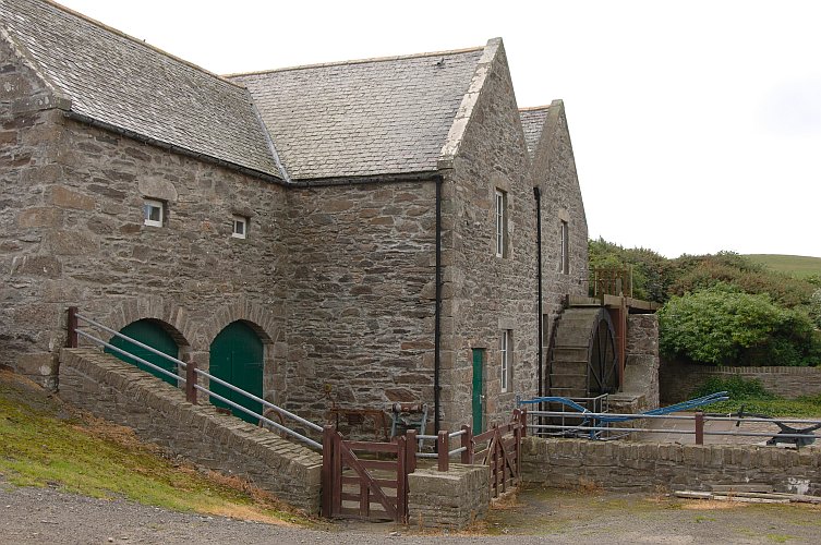 Quendale Water Mill
 Under the shadow of Fitful Head, this powerful water mill was a labour-saving revolution for farmers and crofters in the late 1860s, replacing traditional ‘click-mills and hand querns for grinding cereals.
Beautifully restored, the mill now houses a visitor centre with an exhibition of old farming methods and croft implements. A video shows the original mill machinery in action. The mill includes a Neighbourhood Information Point, small cafe and gift shop.
Old Scatness
Take time to visit Old Scatness Broch, where an archaeological dig has revealed one of Britain’s most exciting Iron Age villages, with many buildings standing at or near roof height and some still even ‘deco-rated’ with yellow clay! Buried to roof height for nearly 2,000 years under metres of sand and soil, the site is rich in artefacts and has remarkable preservation allowing a unique opportunity to better understand the past. Onsite interpretation, guides and Living History demonstrations of ancient crafts/skills help to illustrate how our earlier ancestors lived.
The crofthouse next to the site is a camping böd. In 1886 it was the home of an elderly lady, Betty Mouat, who became a national celebrity after drifting alone to Norway on the fishing smack Columbine.
Jarlshof
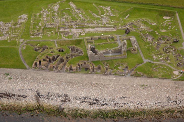 Aerial View of Jarlshof
 Officially described as “one of the most remarkable archaeological sites ever excavated in the British Isles”, Jarlshof came to light a hundred years ago when violent storms exposed massive stonework under a grassy mound above the extensive sandy beach at the West Voe of Sumburgh. There are six main levels, from a Stone Age hut perhaps 4,000 years old, through an Iron Age broch and wheelhouses to a sizeable Viking village and medieval farmstead. As at Old Scatness, less than a mile away, successive layers were buried by wind-blown sand, preserving artefacts now on show in the on-site visitor centre, next to the Sumburgh Hotel.
Sumburgh Head
Shetland’s first lighthouse, on Sumburgh Head, is a listed building. It was built by Robert Stevenson, who accompanied Sir Walter Scott to Shetland in 1814 - a cruise that produced his novel “The Pirate”. The story is set around Jarlshof and Fitful Head and gave Jarlshof its name. The RSPB’s nature reserve at Sumburgh Head has the UK’s most accessible colony of Taamie Nories (Puffins), although the comical little birds only come to land between April and late July. Just park, walk to the lighthouse, look over the wall and there they are, along with Loom (Guillemots), Rippack Maas (Kittiwakes) and Skarfs (Shags). Seals often haul out on the rocks below. If you are lucky, particularly in June and July, you may see Humpback, Minke and Killer Whales, as well as the more common Harbour Porpoises, all feeding in the swirling tides around the tip of the South Mainland.
Another good birding spot is the roadside by the Pool of Virkie, on the airport’s north side, where your car makes a convenient hide to watch migrating waders, and sometimes Shelduck.
Spiggie Loch and Beach
On the side road from Quendale to Scousburgh you pass Spiggie Loch, an RSPB reserve for wildfowl. In late autumn hundreds of migrating Whooper Swans and Greylag Geese from Iceland pass through here, while in summer Arctic Terns and Great Skuas bathe in the shallows.
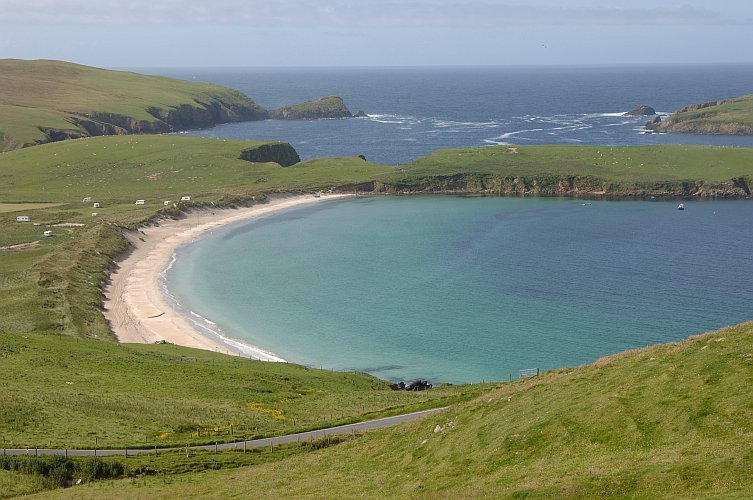 Spiggie Beach
 This is one of the richest lochs in Shetland, with good trout fishing. The burn leading down to Peerie Spiggie Beach is celebrated for sea trout. Nearby, Spiggie Beach makes a popular and sheltered bathing beach. From here look across to other sandy beaches at Rerwick and the fine tombolo beach linking St Ninian’s Isle to the mainland. Midsummer wild flowers bloom on the roadsides and meadows between Scousburgh, Bigton and the sheltered hamlet of Maywick.
St Ninian’s Isle
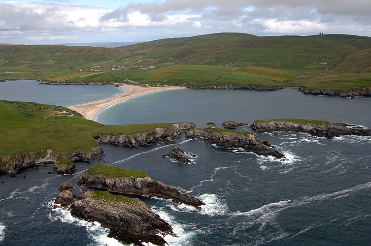 St Ninians Beach
 St Ninian’s Isle became famous in 1958, when a schoolboy helping at an archaeological dig on the island’s tiny Celtic chapel discovered a hoard of silver bowls and ornaments. The treasure, believed to date from around 800AD, is kept in Edinburgh but replicas are displayed at the Shetland Museum and Archives in Lerwick.
Another fine bathing beach is Levenwick, on the east coast just three miles east of Bigton. Nearby is the scenic inlet of Channerwick and the villages of Sandwick and Hoswick, which lie on latitude 60 degrees North – the same parallel as Cape Farewell, Greenland.
Sandwick
The Hoswick Visitor Centre has a wide range of exhibits and displays including an extensive collection of old radios. There is a small cafe, public internet access and a Neighbourhood Information Point. Across the road there is a knitwear factory and shop. The swimming pool is adjacent to the school and there is good coastal walking around the headlands at Cumlewick and Noness. At Burraland the ruins of the crofthouses are a reminder of how communities were cleared from their homes to make way for sheep.
The nearby broch remains look across the sound to Mousa Broch.
The restored boatsheds at Sandsayre combine the waiting room for the Mousa ferry with marine, historical, cultural and environmental displays. A former Mousa ferry flit boat has been restored and forms part of the display. The facility has also retained an open-plan working space for small boat maintenance, repair and restoration.
Cunningsburgh
At Catpund, on the hillside above the main Sandwick to Cunningsburgh road, the ancient inhabitants of Shetland worked steatite, or soapstone. The rock is soft and easy to carve but hardens when subjected to heat. Along the Catpund Burn you can still see the shapes left hundreds of years ago as bowls, urns and other utensils were hacked out of the rock.
A detour through the village of Cunningsburgh, site of the annual agricultural show, brings you to the quiet inlet of Aiths Voe, surrounded by flower meadows.
To the east is fine walking country on Helliness, with views of Bressay and Noss.
The next side road goes through the old crofting township of Fladdabister, where there are the ruins of lime kilns used until the early 20th century. There is spectacular scenery following the coastline north to Quarff.
Easter and Wester Quarff lie at opposite ends of one of Shetland’s few east-west valleys. Here the ice burst through the grain of the landscape and carved a classic glacial valley where the Atlantic and the North Sea are less than two miles apart.
Shetland Ponies
Just north of Quarff, the lay-by next to the Loch of Brindister is one of the best places to meet Shetland Ponies, bred at the farm nearby. Out in the loch, a tiny island holds the ruins of a dun, a prehistoric fort. Returning to Lerwick, the main road skirts Gulberwick, where the Viking Earl Rognvald was wrecked in 1148AD. Above the farm of Wick is the Hollanders’ Knowe, a traditional trading place between islanders and the Dutch fishermen in the 17th and 18th centuries.
Some Useful Information
| Ferry Booking Offices: | Mousa, Tel: 01950 431367; Fair Isle, Tel: 01595 760222 |
| Information Points: | Sumburgh Airport, Quendale Mill, Hoswick Visitors Centre |
| Shops: | Dunrossness, Toab, Levenwick, Bigton, Sandwick, Cunningsburgh |
| Fuel: | Dunrossness |
| Public Toilets: | Grutness Pier, Sumburgh, Sandwick, Bigton, Dunrossness, Cunningsburgh |
| Places to Eat: | Sumburgh, Spiggie, Bigton, Hoswick |
| Post Offices: | Dunrossness, Toab, Bigton, Sandwick |
| Public Telephones: | Grutness, Sumburgh Airport, Toab, Bigton, Levenwick, Sandwick, Cunningsburgh, Quarff, Gulberwick |
| Museums and Visitors Centres: | Jarlshof, Scatness, Quendale Mill, Boddam, Hoswick, Sandsayre |
| Swimming Pool: | Sandwick, Tel: 01950 431511 |
| Churches: | Dunrossness, Bigton, Sandwick, Cunningsburgh, Quarff, Gulberwick |
| Health Centre: | Levenwick, Tel: 01950 422240 |
| Police Station: | Dunrossness, Tel: 01950 460707 |


